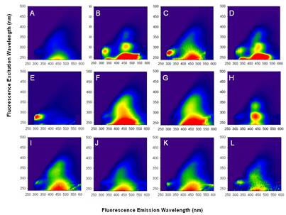
Estuaries and coastal wetlands exist in the transition zone between aquatic and terrestrial environments, and are dramatically affected by anthropogenic activities, changes in hydrological patterns and land-use modifications, with important consequences for the complex processes and exchanges taking place in these highly dynamic coastal margins. Knowledge of the linkages between possible climate-related changes, watershed processes and water quality is critical for better protection of European coastal waters. Changes in water cycling and resulting alteration of precipitation patterns and coastal watershed characteristics (e.g. size, vegetation, soil composition, water storage, retention of carbon) directly affect atmospheric deposition to catchments and surface waters, river discharges, and watershed runoff. These, in turn, affect biogeochemical processes in aquatic ecosystems through changes in nutrient delivery, carbon fluxes, and transport of contaminants to estuaries, coastal waters and the ocean. Many of the hydrological, photochemical, and biological processes that affect the transport, distribution, degradation and fate of terrestrially derived dissolved and particulate mater in the coastal zone, remain poorly characterized. As a consequence, our ability to accurately model these processes, as needed for developing effective mitigation strategies and addressing socio-economic issues related to water resources, is limited. Moreover, insufficient knowledge of the composition and optical quality of these substances and their effect on coastal water optical characteristics currently interfere with our ability to accurately interpret satellite ocean-colour imagery (e.g. MERIS, MODIS, SeaWIFS) in near-shore regions, hindering effective application of remote sensing techniques in carbon and climate change studies. HCMR researchers, in close collaboration with international partners from European and US academic and research centers, lead a highly interdisciplinary and comprehensive experimental effort that focuses on two main research topics: (i) determine how changes in water and energy cycles, due to natural and anthropogenic processes, affect exchanges of nutrients and pollutants, and particularly carbon cycling and fluxes of organic compounds in wetlands and coastal waters; (ii) examine the effects of terrestrial inputs on water photochemical and biogeochemical processes, optical properties, underwater light fields and coastal ocean colour. Our field studies include measurements of meteorological and water physicochemical, optical and biological parameters, and focus on rivers, deltas and watershed systems of the Eastern Mediterranean. Many of these systems are officially protected due to their ecological value. Results from these efforts and integration of observations into watershed (surface/sub-surface and ground water) transport models will contribute towards improving understanding of the linkages between hydrological processes, sources/sinks of dissolved and particulate matter, coastal water quality, and ecosystem functioning in the Mediterranean. A comprehensive and detailed database has been created as part of our field campaign program, which fills critical gaps in current knowledge related to the sources, transformation and fate of organic compounds, nutrients and pollutants in coastal E. Mediterranean. In-situ observations include measurements of hydrological and physicochemical parameters (e.g. water depth, river discharges, pH, water temperature, conductivity, dissolved oxygen, turbidity, salinity). These measurements have been integrated into the HCMR/IIW database, which is available through the website:http://www.lakenet.gr/. Laboratory measurements on collected samples included measurements of ions and nutrients, Chlorophyll-a concentrations, dissolved organic carbon (DOC), dissolved organic nitrogen (DON), dissolved organic phosphorus (DOP), carbohydrates, particulate organic carbon and nitrogen POC/PON analyses, stable isotope analyses, and DOM molecular weight distribution and polydispersity (based on SEC-HPLC anlaysis), coloured dissolved organic matter (CDOM) absorption spectra and estimates of absorption spectral slopes, CDOM synchronous fluorescence spectra, emission scans, excitation scans, CDOM fluorescence excitation-emission matrices (EEMs), CDOM fluorescence yield,. Measurements were performed at various locations in each studied wetland system, from the upstream part of the basin to the estuary, depending on the different hydrologic and land use characteristics of the study catchment and the potential DOM sources in each system (agricultural drainage, riparian vegetation, sewage, freshwater or salt marsh vegetation, swamps, lagoons, etc). Measurements were performed in different seasons, to study processes in terms of seasonal changes in water flow and biogeochemical exchanges. Our results show that, although the Mediterranean Sea is an extremely oligotrophic region, DOC and CDOM amounts in Eastern Mediterranean coastal wetlands can reach high values of the order of those typically measured in highly eutrophic, optically complex, estuarine systems. Considerably higher DOC, aCDOM, fluorescence, DOC-specific CDOM absorption were typically observed upstream the rivers compared to the marine-end members, while the absorption spectral slope and fluorescence quantum yield were lower, consistent with the more aromatic/higher molecular weight (MW) signature of the terrestrial DOM components. SEC-HPLCanalysis showed higher average-weight MW and polydispersity associated with the freshwater DOM. During transport along the river and to the sea, CDOM optical properties showed strong gradients and non-conservative mixing between the freshwater and marine end-members. As discussed in our manuscripts [Tzortziou et al., 2011, and Tzortziou et al., In Prep], observed changes in the amount and quality of DOM are most probably due to both additional sources of humic organic compounds, associated with the presence of major anthropogenic pollution sources in most river systems, as well as DOM removal processes (both photochemical and microbial degradation). Measurements of the fluorescence Excitation Emission Matrices (EEMs) of the CDOM collected from the different river systems we studied (Evros, Sperchios, Louros, Arachthos, Evrotas) indicate that fluorescence spectroscopy can be used as an effective monitoring tool for pollution detection and control of industry impacts on river systems (Figure 2). EEMs analysis on CDOM samples collected from the Evros transboundary river revealed the presence of a major input of anthropogenic pollution between the cities of Tychero and Kipoi, associated with discharges from the Ergene river. Many industrial plants, including leather tanning and textile industries (normally applying treatment), discharge their wastewater to the Ergene, one of the most important tributaries flowing into the Evros river from the Turkish side [e.g. ERPER 1997, Güneş et al. 2008]. A recent ecological assessment in the Ergene river reported that the river water has severe toxicity on Vibrio fisheri [Güneş et al. 2008]. The construction of a small embankment dam upstream the Evros delta at the beginning of the wet season (fall months) significantly influenced freshwater discharges and carbon and nutrient dynamics along the river. Our measurements showed that, when the Evros river dam is open, the fluorescence fingerprint of the pollution input from Ergene (Figure 2B) persists along the full extent of the Evros river and affects the fluorescence signal of CDOM collected from the N. Aegean coastal waters, suggesting the presence of strongly refractory organic carbon compounds [Tzortziou et al., In Prep]. Our measurements in the Sperchios river showed that in-situ deployment of advanced automated systems capable of measuring CDOM fluorescence at specific UV-visible wavelengths could be used for continuous monitoring of anthropogenic wastewater and for
FigureFigure 2: Fluorescence EEMs (A)-(F) Evros river: (A) Fresh-water end-member. (B) Anthro-pogenic DOM input. (C) Coastal site not affected by DOM input in (B). (D) Coastal site affected by DOM input in (B). (E) Marine end-member. (F) Marsh-DOM. (G) DOM exported from the Chesapeake Bay marshes. (H)-(J) Sperchios river: (H) Sperchios site inflenced by run-off from a paper factory (fluorescent peaks are characteristic of Fluorescent Whitening Agents, compounds used during paper manufacturing). (I) Freshwater end-member. (J) Wetlands in Sperchios. (K) Louros, delta area in Amvrakikos, brackish wetlands. (L) Arachthos river in Amvrakikos, freshwater end-member. tracing the dispersion of effluents from paper-mills. Measurements of CDOM fluorescence on samples collected from a site in the Sperchios river influenced by runoff from a paper factory revealed the presence fluorescence centers (Exc/Em: 280/430 and 330/430) characteristic of compounds commonly added to laundry detergents and used during paper manufacturing (i.e. distyrl biphynl (DSBP) and diaminostilbene types, DAS1 and DAS2) (Figure 2H). These results have several direct applications, and suggest that in-situ fluorescence measurements could be particularly useful in water quality monitoring and surveillance programs that require discharges in river systems meet national discharge standards [Tzortziou et al., In Prep]. Our chemical analyses and measurements of DOC, DON and DOP composition and dynamics provided new data and novel information on the sources, quality, and elemental, isotopic and molecular composition of DOM in eastern Mediterranean catchments. Our studies focused on the various biogeochemical processes taking place within the studied river systems under different hydrological conditions. The concentrations and ratios of NO3-, NH4+, PO43-, DOC, DON, DOP were evaluated on a temporal and spatial basis. Additional information on DOM composition has been provided through simultaneous measurements of carbohydrates (TCHO, PCHO), while the data on isotopic signature (δ13C %o) of our samples provided insights on the importance of the various DOM sources. As discussed in the presentations by Tzortziou et al. [2010] and Pitta et al [2010] and in Zeri et al. [2011, In Prep], intensive industrial and agricultural activities, and extensive use of N based fertilizers and organophosphoric insecticides in the Evros basin result in waters enriched in DOC, DON, and DOP concentrations. Elevated inorganic nitrogen loads in Evros River originating either from agricultural runoff (mainly as NO3-) and/or from anthropogenic inputs (mainly as NH4+), give rise to substantial autotrophic production as inferred from the high chl-a and oxygen supersautration values, especially during summer months with low water flow. DOM composition in Evros waters seems to be dominated by authochthonous and anthropogenic material rather than terrestrial. This is suggested by the relatively low DOC:DON and DOC:DOP ratios, the positive correlation of DOC vs chl-a and the
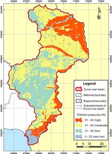
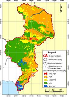
A.
B. Figure 3: (A) Hazard map and (B) Pollution risk map in Evros river catchment (Greek part). decoupling between DOC and DON. The fluctuations of DON, NO3- and NH4+ provide evidence that DON was demineralised through ammonification and nitrification processes. Nevertheless during the dry period, organic nitrogen forms become an important TDN constituent (at least 40%) transported to shelf waters, but the availability of this DON to marine microorganisms remains questionable. DOP on the other hand showed an invariable contribution to TDP export during both seasons (~15%). These mechanisms result in important self-regulation ability during summer, with ~47% of TDN and of TDP retained in the estuary. The residence time of nutrients and DOM in the estuary however, as well as the exact processes which determine their fate (respiration, nitrification, flocculation, sedimentation) are issues of further research in order to clarify the role of Evros River in regulating nutrient availability in shelf waters of the Aegean Sea. Managing water resources, in terms of both quality and quantity, in transboundary rivers is a difficult and challenging task that requires efficient cross-border cooperation and transparency. The Evros trans-boundary river is the longest river in the Balkan Peninsula and the most important one, in terms of freshwater discharge, flowing into the Aegean Sea in Eastern Mediterranean. With a catchment area that is shared by three countries (Bulgaria, Turkey and Greece) currently having inadequate water resource management agreements, the river suffers from increased pollution and deteriorating water quality. Our extensive and comprehensive water monitoring program in the Ervos basin incorporated physical, chemical, biological and optical parameters to assess the environmental status in the Greek part of the river and identify associated pollution pressures. Detailed chemical and optical analyses were performed and a series of parameters were measured in-situ, including nutrients, heavy metals, microbiological loads, macroinvertabrates and fish distribution and abundance, in different seasons during 2008-2010 and along transects extending more than 70 kilometers in the Evros river, to resolve seasonal variability and spatial gradients in water quality and relations to hydrologic conditions and anthropogenic influences in this system. A groundwater pollution risk assessment was conducted in the Greek part of Evros catchment.Potential land use hazards were mapped and estimated pollution risks were evaluated using water quality data. Groundwater pollution risk assessment is an important tool that is extensively used to estimate pollution pressures and optimize land planning processes. As discussed in the manuscripts
|
Predicting Floods With Distributed Hydrological Models
Using Satellite Data to Study Water Cycle Parameters
Measuring Rainfall Using Mobile Weather Radar
Measuring Rainfall over the Oceans Using Underwater Sound Data
Numerical Weather Prediction Air- Sea interactions
Coastal Ecosystem and Water Quality Climate Research
Soil Water - Climate interactions
|
Hellenic Center for Marine Research - Institute of Inland Waters PreWec Marie Curie Excellence Research Team |
 |
People