Hellenic Center for Marine Research - Institute of Inland Waters

PreWec Marie Curie Excellence Research Team


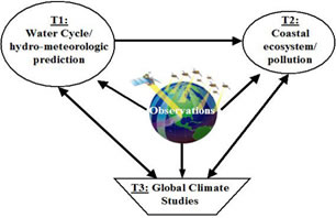
A basic representation of the proposed research framework is shown in Figure 1. Description of the tasks as well as interactions between tasks and observations is provided below:


Figure 1: The proposed research framework, interactions between the various tasks, and the connections with space-based observations; Description of Interactions: Observations are needed in all three tasks; T1 feeds T2 with water cycle predictions (watershed discharge and river runoff fluxes); T1 and T2 feed T3 in terms of definitions of process-level and-vegetation-coastal-atmosphere interactions; and T3 feeds back to T1 and T2 in terms of estimating the impact of climate changes on water resources (quantity and quality) over a variety of spatial and temporal scales.


T1-Watercycle/hydro-meteorologic prediction:

This task aims at delivering an advanced integrative data-modelling system for the simulation of high-resolution continental hydrologic quantities, and characterizing of their uncertainty. A multi-tiered approach is proposed that involves the following steps: (1) improve the accuracy of high-resolution (0.05-0.1 deg, hourly) overland precipitation retrieval through optimal combination of multi-platform (passive microwave and Global-Infrared) satellite sensors and the use of continuous long-range lightning observations (Morales and Anagnostou, 2003; Chronis et al. 2004); (2) use regional lightning observations as a mean to consistently integrate satellite retrieved rain rates with atmospheric model-predicted surface meteorological/radiation forcing variables into land surface models (Papadopoulos et al. 2005); (3) implement a stochastic framework to characterize the integrative data-modelling uncertainty in the form of ensemble simulations (Hossain and Anagnostou 2005); (4) assess the integrative framework on the basis of control experiments at selected data-rich regions in Europe and West Africa having contrasting hydro-climatic conditions (semi-arid versus humid); and (5) use the integrative uncertainty framework to study the scale dependence of predictability in water and energy cycle at the two major continental convective regimes, Africa and the Amazon basin. Our working database includes, (1) radar (PR) and radiometer (TMI) observations from TRMM satellite, (2) passive microwave observations from SSM/I, (3) ½-hourly global Infrared (global IR) brightness temperature fields, (4) lightning location, flash rate and polarity information from our long-range lightning monitoring network (named ZEUS) covering Europe, Africa, South America and surrounding waters, and (5) in situ hydro-meteorological measurements (ground radar, rain gauges, soil moisture and stream flow measurements, meteo stations, etc.) from data-rich sites in West Africa (available through AMMA project) and Europe (available from HYDRATE and RAINCLOUDS communities).

T2-Coastal ecosystem/pollution:

Biological, physical, and geochemical processes, such as marine primary production, tidal mixing, wetland discharges, and strong riverine inputs of geochemically distinct terrestrial organic matter, make the near shore waters of the Mediterranean important and dynamic regions of carbon fixation, transformation, and cycling. Changes in hydro-meteorologic conditions and water/energy cycling and disruption of coastal wetland characteristics can alter delivery of water, dissolved organic mater, sediments, and nutrients to the coastal zone. The resulting changes in coastal water quality and carbon dynamics, however, remain largely unknown. Moreover, optically active substances of terrestrial origin (e.g. dissolved organics leached from plants) play a major role in determining coastal ocean color, as well as the amount and quality of the photosynthetically active radiation available to phytoplankton and benthos (e.g. Tzortziou et al., 2005a).

Understanding variability in the amount, composition, and optical properties of the various water components in the Mediterranean coastal zone is critical for accurate interpretation of ocean color data and application of satellite imagery to coastal monitoring, assessment, prediction, and resource management. As part of this task: (1) we will investigate how changes in hydro-meteorologic conditions and terrestrial inputs of matter affect carbon fluxes and more specifically dissolved organic carbon dynamics in the coastal waters of the Mediterranean; (2) we will use compositional and optical analysis that will include absorption and fluorescence spectroscopy (e.g. Tzortziou et al., 2005a) to examine variability in the concentration, composition, and optical properties of the material introduced to the coastal zone through river run off and wetland discharge, and we will determine effects on coastal water quality; (3) we will apply detailed radiative transfer modeling (e.g. Tzortziou et al., 2005c) to study how changes in water/energy cycling and terrestrial inputs affect underwater light availability and coastal ocean color; (4) Ground-based observations (new and existing datasets) and radiative transfer model results will be used to derive improved bio-optical algorithms for effective interpretation of satellite ocean color imagery (e.g. MODIS, MERIS, SeaWiFS) in coastal waters.

T3-Global climate studies:

Coupled land-atmosphere modelling is a commonly used approach to addressing the question of "what are the effects of surface hydrologic processes on Earth's climate", for which the representation of surface hydrological processes and their feedback to the atmosphere is of the utmost importance. However, without solving the fine-scale (both sub-grid and sub-"time step") variability of precipitation, global climate models severely underestimate precipitation intensity, even if the total precipitation amount may correctly be predicted. In this task we aim at addressing this problem by combining satellite rainfall observations with models. Proposed activities include: (1) Develop, based on precipitation observations, a model-grid-scale distributed climatological database of precipitation frequency and in-storm (non-zero) rainfall intensity statistics with temporal and spatial resolutions suitable for use in climate models. This will be achieved by combining a number of multi-platform/multi-sensor rainfall observations from space including the passive microwave sensors aboard earth orbiting platforms and the visible/infrared sensors aboard geo-stationary platforms; (2) develop a scientifically robust and computationally efficient parameterisation on the impact of fine-scale precipitation and canopy storage variability, which incorporates the above satellite database on precipitation frequency and rain rate statistics into climate models to better estimate land-atmosphere flux exchanges, thus more realistically simulating the impact of surface hydrological processes on the Earth’s climate system (Wang et al. 2005). In addition, to enhance the model capability in simulating seasonal climate variability and in predicting long-term climate changes, we will (3) incorporate a predictive vegetation phenology scheme and a dynamic vegetation model, thus further improve our assessment of land-vegetation-atmosphere flux exchanges; and (4) investigate how the refined representation of land-atmosphere interactions further enhanced by the vegetation dynamics/phenology schemes impacts surface hydrological and climate change modelling using both stand-alone land surface models and coupled global land-atmosphere models.


References

Anagnostou, E.N., 2005 (in press): Assessment of satellite rain retrieval error propagation in the prediction of land surface hydrologic variables, Book Chapter in Measuring Precipitation from Space: EURAINSAT and the Future, (eds) V. Levizzani, P. Bauer and F.J. Turk. Kluwer Academic Publishers.

Hossain, F., and E.N. Anagnostou, 2005: Numerical Investigation of the Impact of Uncertainties in Satellite Rainfall and Land Surface Parameters on Simulation of Soil Moisture. Advances in Water Resources, Volume 28, Issue 12, December 2005, Pages 1336-1350.

Kim Y and Wang GL, 2005: Modeling seasonal vegetation variation and its validation against Moderate Resolution Imaging Spectroradiometer (MODIS) observations over North America, JGR - Atmospheres, 110, D04106, doi:10.1029/2004JD005436.

Mitchell, K.E., Lohmann, D., Houser, P. R., Wood, E. F., Schaake, J. C., Robock, A., Cosgrove, B., Sheffield, J., Duan, Q., Luo, L., Higgins, W. R., Pinker, R. T., Tarpley, J. D., Lettenmaier, D. P., Marshall, C. H., Entin, J. K., Pan, M., Shi, W., Koren, V., Meng, J., Ramsay, B. H. and Bailey, A. A., 2004: The Multi-institution North American Land Data Assimilation System (NLDAS): Utilization of multiple GCIP products and partners in a continental distributed hydrological modeling system. J. of Geoph. Res.-Atmospheres, 109:doi:10.1029/2003JD003823.

Morales, C., and E.N. Anagnostou, 2003: Extending the Capabilities of High-frequency Rainfall Estimation from Geostationary-Based Satellite Infrared via a Network of Long-Range Lightning Observations. Journal of Hydrometeorology, 4(2), 141-159.

Papadopoulos, A., T.G. Chronis and E. N. Anagnostou, 2005: Improving Convective Precipitation Forecasting Through Assimilation of Regional Lightning Measurements in a Mesoscale Model, Monthly Weather Review, Vol. 133, 1961–1977.

Tzortziou, M., Neale, P., Gallegos, C., Osburn, C., Herman, J., and Megonigal, P., 2005a: Sources and cycling of Chromophoric Dissolved Organic Material in the estuarine waters of the Rhode River sub-estuary and the Chesapeake Bay, ASLO Summer Meeting 2005, Santiago de Compostela, Spain, 19-24 June.

Tzortziou M., A. Subramaniam, J. Herman, C. Gallegos, and P. Neale, 2005b (submitted): Remote Sensing Reflectance and Inherent Optical Properties in the Chesapeake Bay waters, Estuarine Coastal and Shelf Science

Tzortziou M., J. Herman, C. Gallegos, P.Neale, A. Subramaniam, L. Harding, and Z. Ahmad, 2005c (submitted): Optical properties and radiative transfer in the Chesapeake Bay estuarine waters: An in-water optical closure experiment, Estuarine Coastal and Shelf Science

Wang DG, Wang GL, Anagnostou EN, 2005: Use of satellite-based precipitation observation in improving the parameterization of canopy hydrological processes in land surface models. Journal of Hydrometeorology, 6, 745-763.

Wang GL, and Eltahir EAB, 2000: Impact of rainfall sub-grid variability on modeling the biosphere-atmosphere system. Journal of Climate, 13, 2887-2899.


Predicting Floods With Distributed Hydrological Models


Using Satellite Data to Study Water Cycle Parameters


Measuring Rainfall Using Mobile Weather Radar


Measuring Rainfall over the Oceans Using Underwater Sound Data


Numerical Weather Prediction Air- Sea interactions


Coastal Ecosystem and Water Quality

Climate Research


Soil Water - Climate interactions