Satellites have improved our ability to predict large-scale weather events (such as hurricanes) and to understand weather changes (such as urban modifications of local climates). However, they have not yet provided accurate information on overland precipitation processes, which scientists need to better monitor and forecast water resources.
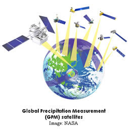
A new space mission, Global Precipitation Measurement (GPM), aims to increase the scientific understanding of the earth’s water cycle, climate, and weather, through frequent and more accurate global measurements of precipitation. GPM will measure rain rates ranging from one-hundredth of an inch to more than four inches per hour. It will allow scientists to estimate the sizes of precipitation particles and to distinguish between snow and rain. GPM data will be available to users within three hours of observation time.
A joint mission of the U.S. National Aeronautics and Space Administration (NASA), the Japanese Aerospace Exploration Agency (JAXA), and other international partners, GPM is scheduled for launch in 2013. It will consist of a core spacecraft and a constellation of support satellites.
|
It is expected that GPM data will be useful in agriculture, public health, public safety, water resources management, forestry, oceanography, aviation safety, and other fields. As the design of the project continues, NASA is seeking feedback from potential users of GPM data to make the mission as effective as possible.
HCMR researchers, in close collaboration with international partners, will assess the potential of current and anticipated space-based observations to improve predictions of floods and water cycling. Their questions include the following: How well can we predict floods and water cycling from existing satellite observations of precipitation? What improvements can we anticipate from new GPM data? How do the uncertainties of such variables as runoff, soil moisture, and energy fluxes affect the usefulness of the data in various applications, including water management, agricultural planning, and flood warnings?
The answers to these questions will help scientists understand the best uses of satellite products and their application to decision making for water and disaster management.
|