Storms formed in the Mediterranean basin frequently generate strong precipitating systems that can lead to flash floods in coastal and mountainous basins. This is due to the intense air-sea interaction processes such as, sea spays and wave breaking, that feed the atmosphere with vapor and aerosols, which is critical to the formation of storms. Sea surface temperature (SST) is another key component of the air-sea interface that can significantly affect precipitating systems formed over the ocean and around its coastal areas. The largest ocean heat loss comes from evaporation that withdraws heat from the ocean surface transferring it to the atmosphere boundary layer (BL). If the atmosphere is unstable this energy soon becomes available once the vapor condensate into water droplets at a higher level. The heat released by condensation provides buoyancy to the moist air increasing the updraft that feeds the storm and enhances precipitation. Apart from the vertical exchanges, the horizontal temperature gradients on the edge of oceanic currents can affect the turbulent fluxes in the marine BL, promoting the increase of wind speed with the increase of the SST gradient. Numerous studies found relations between wind speed /breeze circulation and SST perturbations, which can also affect rainfall estimation by numerical weather prediction (NWP) models. Another point to note is that reproduction of storm systems by a NWP model is influenced by its resolution. A storm simulated with a finer grid resolution should better define heat fluxes at the oceanic mixed layer, which directly affects feedback on atmospheric convection and as consequence, offering more realistic representations of cloud cover.
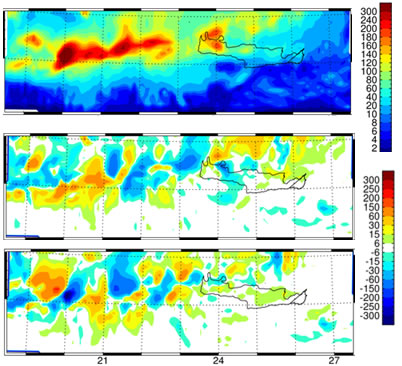
Figure 1: Model simulation of the storm total (16-19 October 2006) precipitation (upper panel) and differences between the two SST scenarios (lower two panels)
Researchers at PreWEC evaluated the importance of the SST initialization on the simulation of a maritime storm (16-19 October 2006) that caused major flash floods in Western Crete Island. The storm initiated over the sea and gained strength by the mountainous terrain when reached the island. The flash flood is investigated in-depth, in terms of model simulated rainfall and different SST fields. The model simulation performance is verified against in-situ measurements over the island. The study carries on simulations with different sources of SST fields, with low and high resolution and with single and daily SST initialization. To investigate SST initialization effects the study compared control simulations generated with NOAA NCEP RTG SST (0.5 deg resolution) against two experimental runs, first using high resolution (0.02 deg) SST acquired from Medspiration database and the second using SST fields from the same data source up-scaled to resolution correspondent to the NCEP RTG SST. The study shows that all three simulations depicted the storm and produced high precipitation over the flooded basins in Western Crete. Bulk statics indicated low bias and high correlation between the control WRF simulations and local surface gauges. The study shows and analyzes differences among the storm propagation patterns over ocean associated with the different SST initializations. Results show that the most significant effect of SST initialization is on the mixed phase water content (graupel/ice/snow) produced by the model’s microphysical scheme over the complex terrain.
|
Predicting Floods With Distributed Hydrological Models
Using Satellite Data to Study Water Cycle Parameters
Measuring Rainfall Using Mobile Weather Radar
Measuring Rainfall over the Oceans Using Underwater Sound Data
Numerical Weather Prediction Air- Sea interactions
Coastal Ecosystem and Water Quality Climate Research
Soil Water - Climate interactions
|
Hellenic Center for Marine Research - Institute of Inland Waters PreWec Marie Curie Excellence Research Team |
People


