Because it varies greatly in time and space, rainfall is very difficult to measure. Yet accurate rainfall measurements are necessary to understand the water cycle and to forecast the weather and its consequences, such as river floods and flash floods.Improving these forecasts requires accurate measurement of rainfall over short time periods (minutes) and large areas (hundred of square kilometers). The rainfall may come from various weather systems, ranging from cold fronts to thunderstorms to tropical depressions. These diverse weather systems present challenges to current measurement technologies.
Weather radar has been widely used to monitor precipitation. For example, National Weather Services in Europe use extensive networks of Doppler radar systems for weather surveillance. These systems represent major advances in monitoring rainfall and therefore improving real-time forecasting of river floods and flash floods. However, rainfall estimates based on the current national radar networks have technical limitations.
This experimental project is testing a state-of-the-art mobile observatory to overcome these limitations.
|
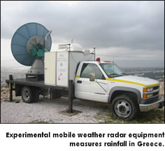
It uses the modern technologies of X-band (high frequency) and dual-polarization radars. X-band radar can be small, portable, sensitive to small particles in the atmosphere (like drizzle and snow), and versatile. It requires low power yet provides high-resolution images. Dual-polarization radar can provide more accurate estimates of precipitation than can standard single-polarization radar. It can also distinguish between different types of precipitation (such as heavy rain, hail, and snow).
These technologies may offer low-cost solutions for the study of small-scale water basins in remote areas, but they too have significant technical limitations. Researchers at HCMR in collaboration with the National Observatory of Athens are working to address some of those limitations.
If the mobile observatory proves reliable, it will be a useful and cost-effective way to fill critical gaps in the current national radar network. The use of small, economical X-band radar units would be especially helpful in regions prone to localized severe weather phenomena, like tornados and flash floods, and over mountainous basins that are not well covered by existing radar networks |